Landscaping/Urban Forestry
Through implementation of long-term planning documents such as the Urban Forest Management Master Plan and Parks and Open Space Master Plan, the City of St. John's is committed to cultivating an urban forest that is diverse, attractive and sustainable and enhancing and building upon the City’s existing network or parks, green spaces, trails and tree-lined streets.
One of the primary ways of achieving the goals outlined in these documents is working with private landowners through the City’s development review process. In doing so the City aims to ensure that where feasible, existing natural resources and parklands are protected and retained, and that space is provided to support the successful planting of trees, establishment of landscapes and development of new park amenities.
Cities such as St. John's are in a constant state of change. Development enables cities to adapt to meet the needs necessary to facilitate such change. It is the role of City staff to guide development based upon the decisions of City Council such that what's deemed best in the public interest is achieved. In this instance staff need to work with the development community to find a balance between developing natural areas and protecting the functions that natural ecosystems provide.
The City’s Landscape Development Policy attempts to find this balance by providing direction, through a list of requirements, pertaining to the preservation and enhancement of the city’s natural environment within the context of new development. The requirements are applicable to all levels of development proposed within the city of St. John’s, regardless of size, cost or level of complexity.
Requirements
Tree Protection
Snow Storage
Tree Spacing and Location
Species Diversity
Species Selection
Stock Type and Size
Relocation of Trees
Establishment
Parks and Open Space Master Plan Requirements
Tree Planting Detail
The policy is guided by the City’s Municipal Plan, Urban Forest Management Plan, Parks and Open Space Master Plan and other direction provided by City Council. These requirements offer guidelines for developers and property owners to align with the City’s vision for future development.
1. The existing landscape character shall be preserved to an extent reasonable and feasible.This includes the preservation of existing trees and incorporation of new trees into the landscape to obtain a tree density as outlined in the City’s Street Tree Planting Standard.
2. Submission of a landscape/site plan identifying the following, prepared by a qualified landscape professional:
- minimum 20% of the total development area to be landscaped
- location, species (common and botanical name) size, condition/stock type and quantity of trees, shrubs and any other plant material proposed
- areas to be sodded or seeded shall identify a minimum of 150 mm of topsoil
- existing trees to be retained and proposed protection, e.g. protective hoarding
- proposed flower beds and planters
- description and locations of hard landscaping
- existing vegetation to be removed
- planting details
- soil specifications
- snow storage plan
- applicable technical requirements of the current edition of the Canadian Landscape Standard
Landscape plans and associated details are required components of development applications. These plans must be prepared by a qualified landscape professional with the requisite skills to interpret construction plans and develop landscape designs that are harmonious with all elements of the proposed development.
Landscape plans should be developed in concert with the overall site development process. Engaging the services of a landscape professional early in the project planning stages can help to ensure alignment with City requirements, avoiding costly delays and revisions at a later stage.
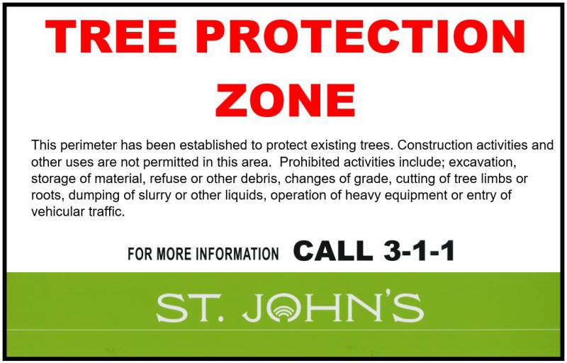
Tree Protection
Existing trees to be protected must be identified on all plans, including landscape plans, where proposed work has the potential to cause damage. In some instances, prior to the start of construction it may be necessary to install protective fencing, establishing a tree protection zone (TPZ), prohibiting the following;
- excavation
- storage of material, refuse or other debris
- changes of grade
- cutting of tree limbs or roots
- dumping of slurries or other liquids
- operation of heavy equipment
- entry of vehicular traffic, etc.
The size of TPZ required is determined based upon the trunk diameter of the tree in question, multiplied by a factor of six (6). For example, a tree measuring 40 cm in diameter would require a tree protection zone of 2.4 m measured from the base of the tree (40 cm x 6 = 240 cm or 2.4 m). The minimum required TPZ is 2.4 m.
Tree protection hoarding is to be constructed of plywood or other rigid material where necessary to block debris from entering the TPZ. Otherwise, TPZ’s can be defined using orange snow fencing attached to rebar, t-rails, or similar posts. Signage must be attached to the fencing identifying the area as a tree protection zone. Below is a sample City of St. John’s Tree Protection Zone sign. This sign may be reproduced for use throughout the city.
Where excavation in close proximity to existing trees to be protected cannot be avoided, hand digging and root pruning may be required. Individual tree assessments will be required in these instances and where minimum TPZ’s cannot be achieved, to determine the tree’s ability to withstand the impact of the proposed work and maintain structural integrity.
Snow removal and storage can have a detrimental impact on trees, shrubs and other vegetation. Through the site design process, consideration must to be given to managing snowfall and ensuring appropriate space is provided to satisfy both the City’s tree planting and snow removal requirements. Applicants are required to describe how snowfall will be managed at the site and identify snow storage areas on the landscape plan.
3. Shrubs/ground cover and other plant materials shall be used to compliment tree planting but shall not be the sole contributor to the landscape. Effective use of earth berms, existing topography and existing vegetation is also encouraged as a component of the overall landscape plan.
4. Trees and shrubs shall meet Landscape Canada Nursery Guide Specifications.
5. Trees and shrubs shall be selected from the City’s Street Tree Planting Standard or those species hardy to Canadian Plant Hardiness Zone 5B, salt tolerant, adapted to environmental conditions at the site, with a proven local history.
6. Trees to be a minimum of; 50 mm caliper - deciduous and 1.25 m in height - coniferous.
7. All landscaping adjacent to paved areas shall be protected by concrete curbs, retaining structures or other protective measures.
8. Landscaping, both at the time of establishment and in future, shall not obstruct vehicular sightlines at street intersections, access drives, parking aisles, etc. nor shall any feature which creates an obstruction of view be located within the site triangle.
- Mature growth – trees, shrubs and other vegetation will grow, the size of the proposed species must be taken into consideration in the context of the proposed planting location.
- Utilities – the presence of utility infrastructure both above and below grade can result in future conflicts, compromising site safety and long-term tree growth.
- Snow – on site snow storage must be considered early and throughout the site design process.Snow storage must be provided in a manner that does not conflict with proposed landscaping or cause sightline obstructions.
9. Refer to the City of St. John’s, Department of Engineering, Specifications Book, for applicable standards of individual features, e.g. tree planting, sodding, etc.
- Topsoil must have a pH level of 6.8 and be free of roots, vegetation, debris and stone greater than 40 mm in diameter.
- There are four different grades of sod:
- Premium
- Standard
- Specialty
- Field
- In addition to the identifying the grade of sod required, property owners may also be required to provide sod with a certain growing medium, e.g. mineral, soil, peat, sand, etc.
- When using seed, seed must be Certified Canada No. 1, have a minimum germination rate of 75% and in the absence of specifying a unique blend, include the following mixture:
- 50-60% Kentucky blue grass
- 20-30% creeping red fescue
- 10-20% perennial rye
- It is important to note that any sod, hydroseed or other turf installation placed in the fall will not be accepted until the following June when it can be determined whether or not the vegetation has established and will survive.
- Topsoil or turf grass shall not be placed prior to May 1st or after November 1st.
- Tree Spacing and Location
- Species Diversity
- Species Selection
- Stock Type and Size
- Relocation of Trees
- Establishment
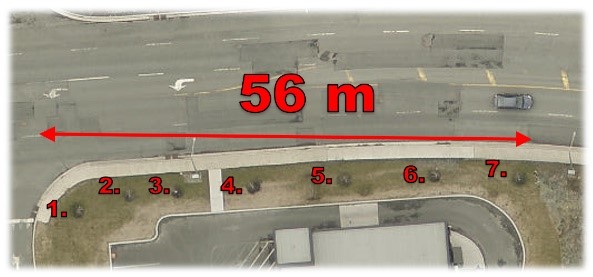
(a.1) Residential - Street trees (minimum one per lot) shall be situated within a front or side yard visible from the road, subject to the line of sight requirements of the St. John's Development Regulations, Section 8.3.3.
The number of trees required is calculated based upon the length of the lot frontage, e.g. a property with a lot frontage measuring 56 m would require the planting of a minimum 7 trees.
|
Lot Frontage = 56 m Tree Planting Requirement = 1 tree/8 m
No. of Trees Required = Lot Frontage ÷ 1 tree/8 m = 56 m ÷ 8 = 7 trees
 |
(b) No tree shall be planted closer than 1.5 m from any driveway, or laneway, nor shall a tree be planted in such a manner that its eventual growth cannot be maintained, so as to avert interference with or obstruction to any improvements installed for public benefit.
- Trees grow; be aware of the mature size of the species chosen.
- Stay away from utilities, both above and below grade.
- Allow room for snow storage and removal from both private and municipal site clearing.
- Fruit, nuts or litter associated with the species selected and potential conflicts with adjacent site uses, e.g. fruit trees proposed in an area with potential to grow over an area designated for vehicle parking.
(c) Trees to be planted in good quality soil consisting of 50% loam, 30% decomposed organic matter and 20% sand.
(d) Cultivated soil to provide for a minimum porous root zone of 1.25 m3 (1.25 m - width, 1.25 m – length and 0.80 m - depth) to enable normal root development and tree establishment. In the instance that these specifications conflict with the City’s Tree Planting Detail, the Tree Planting Detail shall prevail.
(e) Deciduous trees to be supported during the first two years following planting via a 1800 mm metal stake installed at the edge of the root ball. Stakes to be inserted a minimum of 600 mm into the ground facing the prevailing wind. Trees to be attached with gauge 12 galvanized wire or approved equivalent tree tie. Wire to be encased in rubber hose where wire may contact the tree.
When selecting tree species, consideration must be given to; tree size at point of maturity, fruit and nut debris, above and below ground utilities and other infrastructure, adjacent structures, driveways and root growth requirements.
The following is a list of species suitable for planting within the city of St. John’s. Please note each species has specific site requirements, growth habits and other individual characteristics. Careful consideration must be given when selecting a tree to ensure the species matches the proposed planting site. Other species not included below may also be considered subject to the approval of the Municipal Arborist.
| Deciduous | Coniferous |
| Acer platanoides Phellodendron amurense Acer saccharinum Prunus spp. Acer x freemanii Pyrus calleryana Aesculus hippocastanum Quercus alba Aesculus x carnea Quercus coccinea Betula papyrifera Quercus imbricaria Betula pendula Quercus macrocarpa Betula verucosa Quercus palustris Celtis occidentalis Quercus robur Elaeagnus angustifolia Quercus rubra Fagus grandifolia Sorbus spp. Fagus sylvatica Syringa spp. Malus spp. Tilia spp. |
Abies balsamea Abies concolor Chamaecyparis nootkatensis Larix kaempferi Larix laricina Picea abies Picea glauca Picea omorika Picea pungens Pinus nigra Pinus sylvestris Pinus resinosa Pseudotsuga menziesii |
Matching the species to the site is the most critical component of developing a planting plan. Careful consideration needs to be taken to ensure the characteristics of the tree matches the site conditions. Some of the attributes to be considered include; mature height, crown spread, light requirements, shade tolerance, salt tolerance, present soil type, moisture condition, fruit, flower and seed production, native range, adjacent site uses, future maintenance plans, property user preferences, etc.
Planted trees shall be nursery grown, balled and burlapped, container/potted, or wire basket stock. Planted trees shall be of the following minimum size:
- Residential
- Deciduous – 35 mm caliper
- Coniferous – 100 cm high
- Commercial, Educational, Institutional, Open Space
- Deciduous – 50 mm caliper
- Coniferous – 150 cm high
Street trees may be relocated within the tree line to accommodate design features of the property, including the repositioning or widening of driveways, upon approval of the Municipal Arborist.
All tree planting is required to be completed prior to the issuance of a final occupancy permit. If the work cannot be completed for reasons beyond the property owner’s control, e.g. inclement weather, temporary occupancy may be granted under the following conditions;
- outstanding work identified by September 30th must be completed within 60 days,
- whereas, outstanding work noted after September 30th, must be completed by June 30th of the following year.
Implementing and maintaining landscaping in accordance with approved plans is a requirement of the City’s Commercial Maintenance By-law, City of St. John’s By-law No. 618. Where properties do not conform with the by-law, the City may complete the required work to achieve compliance and levy the cost of completing the work against the property owner as taxes due and owing in respect to the property.
Parks and Open Space Master Plan Requirements
St. John’s Parks and Open Space Master Plan describes the vision for the City’s parks and open spaces network and provides a series of requirements for new development to ensure this vision is achieved.
The plan identifies various categories of green space, trails and parks and requirements for each. Property owners are responsible for identifying all existing and proposed parks and open space and their proximity to the proposed development. Parks must be categorized using the classification system included in the City’s Parks and Open Space Master Plan.
Briefly, the park categories identified in the plan include;
- Neighbourhood Park
- Local park, providing easy access to recreation and leisure activities. May include informal court and field play spaces, playground equipment, natural space and access to trails.
- Approximately 1 hectare in size, placed at 20-minute walking intervals (1600 m)
- Community Park
- Strategicaly placed parks designed to meet the needs of several adjacent neighbourhoods.This type of park may include formal sport facilities, expanded play areas and are suitable for hosting community events.
- Between 3.2 and 12.1 hectares in size, placed at 40-minute walking intervals (3700 m – no more than 20 minutes from any resident’s front door).
- Municipal Park
- This is a large, destination park, suitable for a variety of different uses, including festivals and sport tournaments. These sites may include a number of unique features such as; BMX tracks, ice skating trails or rinks, picnic areas, internal walking trails, off-leash dog areas, etc.
- Between 12.1 to 40 ha and above in size, attracting visitors from within a 50 km radius of the site.
- Urban Plaza
- Social gathering sites, typical of downtown or large commercial sites, providing opportunities for social interaction, public markets and small events.
- Location, size and use may vary.
- Neighbourhood Square
- Social focal point for high-density residential or institutional areas. Providing opportunities for rest, recreation or public events.
- Location, size and use may vary.
- Community Common
- This classification refers primarily to existing tot-lots.Where feasible to do so the City will work with local residents to ensure these sites meet the current needs of the surrounding community.
Property owners must review these requirements and classification descriptions in the context of any proposed development to ensure compliance.
The Parks and Open Space Master Plan also identifies two main categories of trails.
- Community Trail – connects neighbourhoods and provides access to frequent destinations within the community. These trails may be single-use or multi-modal depending upon the needs of the community. These trails are essential as they often provide connection to the larger, Municipal Trail network.
- Municipal Trail – larger, multi-modal trail network that exists throughout the City, providing access to key destinations and support alternative means of transportation.
Further detailed information and specifications for different trail types found within these categories, e.g. shared use, cross country skiing, hiking and mountain biking, are included in Appendix B of the plan.